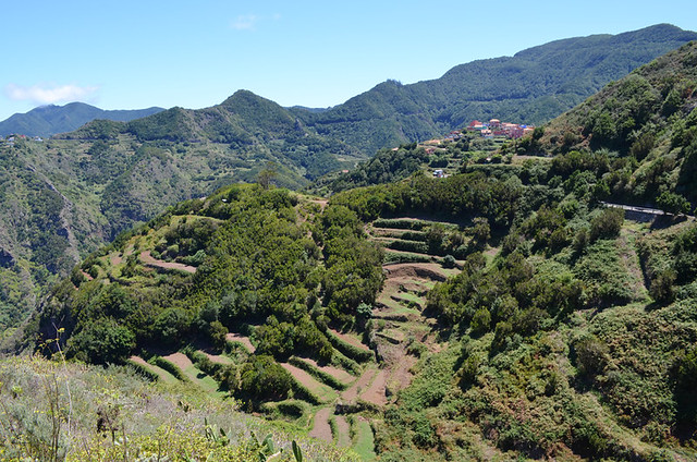
It is a view to make you weep – the saw-toothed Anaga peaks piercing the sky, their green slopes sweeping down to the white houses of Taganana, blinding white in the sunlight. To the east the expanse of marine blue is broken only when it meets the horizon, where it becomes a paler shade of azure.

Since we first set sight on Anaga we’ve walked many, many paths in various countries and still it takes our breath away. The combination of ingredients you find there make it difficult to match, especially when vistas across the dramatic landscape are viewed from a warm and sunny vantage point.
Thirty minutes earlier I’d been trying to capture another Anaga scene – one of dark, bruised skies lying heavy over the lush Aguere Valley as the rain spat venomously. The reason for me risking a sodden camera was a double rainbow which arced flamboyantly across the leaden sky.

An hour after wallowing in the scene above Taganana, we’re walking across the hot, golden sands at Playa de las Teresitas. The thirsty looking hills rising up behind the beach don’t look as though they’ve seen rain in months. This is also Anaga.
Anaga is like nature’s version of that scene in Spartacus: –
“I am Anaga.”
“No, I am Anaga.”

Which is why some who don’t know this remote region of Tenerife can become confused when trying to pin down what Anaga is actually like. This week a Canadian poster on Tripadvisor couldn’t quite get their head around what is ostensibly a simple answer to the question “When is Anaga lush and green?”
The answer is it’s always green and lush, and it’s always brown and arid.
That simple answer might come across as a riddle to anyone who doesn’t know how Tenerife’s micro-climates work.

The big problem in trying to pin down Tenerife’s weather and how it affects the landscape is that it’s a shape-changer. People talk about the differences in weather between the south and north of Tenerife but that’s simplistic in the extreme and often wildly misleading.
Anaga is a prime example of why. It’s all ‘north’, yet the scenes I described previously were all on the same morning in April (you can insert just about any month there). We’ve walked in sweltering sunshine in early March and in bone-chilling damp mist at the height of summer. We’ve also experienced both on the same walking route plenty of times; starting out wrapped in all our layers for warmth and to stay dry as we negotiated slippery, sodden paths through ancient subtropical evergreen laurisilva forest before we end our route in open, arid ground in sweat-sodden t-shirts.

Laurisilva forests thrive only in places with temperate, but humid weather. They are sometimes called cloud forests as they can often be shrouded in a mist which sates the thirst of the flora. It might not be raining, but there can be so much moisture in these clouds that the trees around you are literally dripping wet. When viewed from the other side of a ravine the sight of clouds of steam rising from the Anaga treetops is quite a spectacle to witness. These clouds can descend at any time of the year, they have to for the forest to survive.

An example of the contrasting faces of Anaga can be experienced when descending on foot from Cruz del Carmen to the north coast. After a few kilometres of descent, the dank forest thins out and you emerge into a land of small farmsteads and agricultural terraces, some cut into steep slopes above plunging ravines. As the descent continues, prickly pear and low shrubs take over before even they become sparse and the verdure land morphs again, into one of brown and ruddy hues. We’ve experienced exactly the same on other walking routes in Anaga. On one, our outward route is through dense forest whereas our return route is via a shade-less, rather barren ravine where regular stops are required to splash hot faces with cooling water from a stream which, thankfully, runs parallel to the path.

It’s not necessary to walk for umpteen kilometres to see Anaga’s split personalities, a drive along the road which winds across the ridge rewards with multiple contrasting views. At points you can stand on one side of the tarmac and look down over arid slopes to the coast, before crossing to the other side to gaze over a lush canopy.
When the Canadian hiker who asked about the time of year when Anaga is lush eventually sets foot on its trails he/she will finally understand why “it’s always green and lush, and it’s always brown and arid” isn’t the riddle it sounds.
Our full set of Real Tenerife Island Walks and Real Tenerife Island Walks, Northern Routes include trails which we feel show the best of walking in Anaga whilst our Real Tenerife Island Drives guide includes a driving route through Anaga for those who’d prefer to see it using four wheels.


Be the first to comment